MontereyBreakwater
Breakwater San Carlos Beach
Monterey, Monterey Bay, California
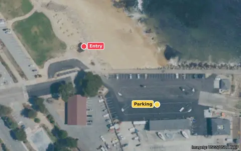
Directions to the entryParking
Moderate WNW wind swell, partly blocked by the Monterey Peninsula: expect some surge near the wall.
High confidence
High confidence: Based on a buoy reading 46 min ago; the forecast has been matching the buoy closely.
Buoy 46236 reading 11:30 AM (56 min ago)Forecast issued Tue, Oct 13, 11:27 AM PDT
Right now
Mediocre: 4 ft of wind swell at 9 s from the WNW (Monterey Canyon buoy), partly blocked here by the Monterey Peninsula; plus 3 ft at 14 s from the W; 7 kt onshore wind.
- Waves here
- 2.7ft estimated
- Buoy swell
- 3.9ft buoy 46236
- Period
- 9s
- From
- WNW 293°
- Wind
- 7kt onshore
- Tide
- 5.5ft
- Water
- 63°F buoy 46236
- Air
- 60°F
"Waves here" is estimated from the buoy and this site's exposure; the buoys are offshore. Wind and air are the NWS forecast for this hour.
When should I dive?
Today
Mediocre→ steadyNow and the rest of today's daylight, roughest hour shown. Rated at 12:16 PM.
Mediocre: 4 ft of wind swell at 9 s from the WNW (Monterey Canyon buoy), partly blocked here by the Monterey Peninsula; plus 3 ft at 14 s from the W; 7 kt onshore wind.
High confidence
High confidence: Based on a buoy reading 56 min ago; the forecast has been matching the buoy closely.
- Waves here
- 2.7ft
- Buoy swell
- 3.9ft
- Period
- 9s
- Wind
- 7ktonshore
High 1:18 AM, 4 ftLow 5:55 AM, 2.7 ftHigh 12:02 PM, 5.5 ftLow 7:26 PM, 0.1 ft
Wed, Oct 14
Good→ steadyBest day this week7 to 11 AM dive window, roughest hour shown. Rated at 7:00 AM.
Good: 2 ft at 14 s from the W (Monterey Canyon buoy), partly blocked here by the Monterey Peninsula, long period so the surge runs deep; plus 2 ft at 6 s from the WNW; plus 2 ft at 16 s from the SSW; 6 kt onshore wind; the forecast's 14 s period disagrees with the buoy's 9 s, so Low confidence.
Low confidence
Low confidence: A forecast about 19 hours ahead; the forecast has been matching the buoy closely.
- Waves here
- 2.1ft
- Buoy swell
- 2.4ft
- Period
- 14s
- Wind
- 6ktonshore
High 2:20 AM, 3.8 ftLow 6:24 AM, 3 ftHigh 12:33 PM, 5.3 ftLow 8:15 PM, 0.3 ft
Thu, Oct 15
Good→ steady7 to 11 AM dive window, roughest hour shown. Rated at 7:00 AM.
Good: 2 ft at 13 s from the WNW (Monterey Canyon buoy), partly blocked here by the Monterey Peninsula; plus 2 ft at 15 s from the S; 8 kt onshore wind; more than 24 hours out while the wave model is still being calibrated, so Low confidence.
Low confidence
Low confidence: A forecast about 43 hours ahead; the forecast has been matching the buoy closely.
- Waves here
- 1.8ft
- Buoy swell
- 2.1ft
- Period
- 13s
- Wind
- 8ktonshore
High 3:37 AM, 3.6 ftLow 6:55 AM, 3.3 ftHigh 1:10 PM, 5.1 ftLow 9:11 PM, 0.4 ft
Fri, Oct 16
Good→ steady7 to 11 AM dive window, roughest hour shown. Rated at 7:00 AM.
Good: 2 ft at 12 s from the WNW (Monterey Canyon buoy), partly blocked here by the Monterey Peninsula; plus 2 ft at 15 s from the SSW; 8 kt onshore wind; several factors near the edge, so rated one step lower; Low confidence.
Low confidence
Low confidence: A forecast about 67 hours ahead; the forecast has been matching the buoy closely.
- Waves here
- 1.7ft
- Buoy swell
- 2.4ft
- Period
- 12s
- Wind
- 8ktonshore
High 5:10 AM, 3.6 ftLow 7:37 AM, 3.5 ftHigh 1:58 PM, 4.8 ftLow 10:14 PM, 0.6 ft
Sat, Oct 17
Good↑ swell building, peaking around 9 pm Sat7 to 11 AM dive window, roughest hour shown. Rated at 9:00 AM.
Good: 2 ft at 7 s from the WNW (Monterey Canyon buoy), partly blocked here by the Monterey Peninsula; plus 2 ft at 14 s from the SSW; plus 1 ft at 13 s from the WNW; plus 1 ft at 19 s from the SSW; plus 1 ft at 11 s from the WNW; light wind; swell building, peaking around 9 pm Sat; several factors near the edge, so rated one step lower; Low confidence.
Low confidence
Low confidence: A forecast about 93 hours ahead; the forecast has been matching the buoy closely.
- Waves here
- 1.9ft
- Buoy swell
- 2.3ft
- Period
- 7s
- Wind
- 5ktlight
High 6:33 AM, 3.7 ftLow 9:03 AM, 3.6 ftHigh 3:04 PM, 4.5 ftLow 11:18 PM, 0.6 ft
Next five days, hour by hour
Tap a stretch of the ribbon for its times and numbers.
Shaded = night. Waves from the NOAA GFS-Wave (WAVEWATCH III) model at buoy 46236, corrected against what that buoy has measured (systematic factor 1.12, seeded until 7 days of data are logged). The rating uses each hour's waves, wind and tide.
Getting in
Easy sandy beach entry at San Carlos Beach Park. Most dives follow the breakwater wall or head out over the sand toward the kelp.
Directions to the entryParking
Red pin: entry. Yellow pin: parking. Points checked against OpenStreetMap and aerial imagery; look the spot over when you arrive.
Live conditions
Each cam opens on its owner's site.
Recent buoy readings buoy 46236, Monterey Canyon Outer
| Time | Waves | Period | From | Water |
|---|---|---|---|---|
| 11:30 AM 56 min ago | 4.6 ft | 9 s | WNW | 63°F |
| 11:00 AM 1 h ago | 4.6 ft | 15 s | W | 63°F |
| 10:30 AM 2 h ago | 4.3 ft | 14 s | W | 62°F |
| 10:00 AM 2 h ago | 4.3 ft | 14 s | W | 62°F |
| 9:30 AM 3 h ago | 4.6 ft | 14 s | W | 62°F |
| 9:00 AM 3 h ago | 4.9 ft | 15 s | W | 62°F |
| 8:30 AM 4 h ago | 4.6 ft | 15 s | W | 62°F |
| 8:00 AM 4 h ago | 4.6 ft | 15 s | W | 62°F |
Randall Spangler's conditions guide · Monterey County Dive Reports
Dive-site information
- Access
- No permit needed.
- Parking
- Paid street parking and lots along Cannery Row and Foam Street. A dive shop, showers and food are right at the site.
- Hazards
- Boat traffic near the harbor mouth, so stay along the wall. Big swells still push surge into the shallows by the wall.
- Skill
- Good for new divers on calm days; the most forgiving entry in the area. Advisory only, not a safety guarantee; always judge conditions yourself.
- Site
- About 10 to 50 ft along the breakwater wall and out over sand and kelp. Only a narrow slice of northwest swell (about 311 to 343 degrees, between Point Pinos and Santa Cruz) reaches the Breakwater directly. The Monterey Peninsula blocks everything from the west and south; what gets in wraps around, and long-period swell wraps best.
Advanced forecast and methodology
Buoy
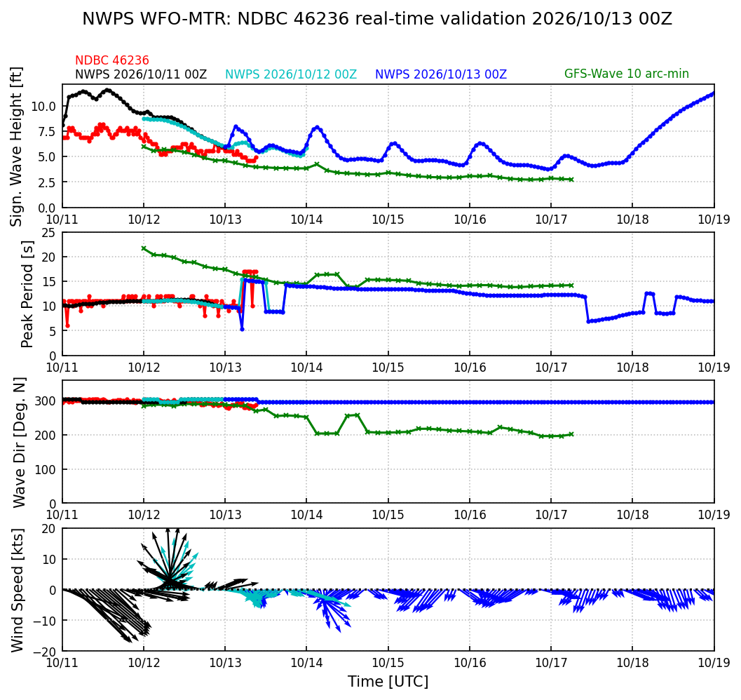
Forecast check: Over the last 36 hours the forecast has matched the Monterey Canyon Outer buoy well (14 readings compared).
Buoy split now: swell 3 ft at 14.3 s from the W, 54% reaches this site; wind waves 3.9 ft at 9.1 s from the WNW, 56% reaches this site.
The chart did not load.
Red dots: the buoy. Blue: the latest NWPS forecast; black and light blue: earlier runs. Green: the global GFS-Wave model. Times are UTC (subtract 7 hours for Pacific daylight time). View the full forecast at NOAA
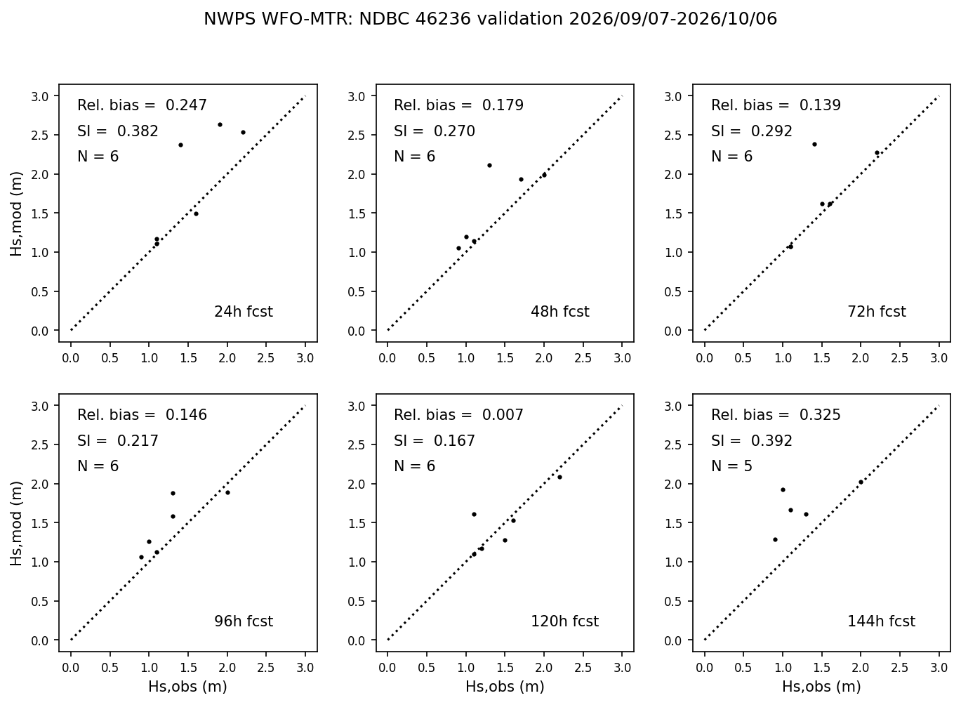
30-day forecast accuracy chart · Our forecast-vs-buoy log (JSON)
Forecast models
Waves from the NOAA GFS-Wave (WAVEWATCH III) model at buoy 46236, corrected against what that buoy has measured (systematic factor 1.12, seeded until 7 days of data are logged). Wind and air temperature come from the NWS forecast for the water off Breakwater, issued Tue, Oct 13, 11:27 AM PDT.
NWS marine forecast: Monterey Bay
Today: NE wind around 5 kt, backing to W early this afternoon, rising to 10 to 15 kt late. Seas 3 to 4 ft. Wave Detail: NW 3 ft at 9 seconds and SW 2 ft at 17 seconds.
Tonight: N wind 10 to 15 kt, becoming NE 5 to 10 kt after midnight. Seas 3 to 5 ft. Wave Detail: W 4 ft at 8 seconds and SW 2 ft at 16 seconds.
Wed: NE wind 5 to 10 kt, backing to W in the afternoon. Seas 3 to 4 ft. Wave Detail: NW 3 ft at 8 seconds and SW 2 ft at 16 seconds.
Wed Night: NW wind 5 to 10 kt, veering to NE after midnight. Seas 3 to 4 ft. Wave Detail: NW 3 ft at 8 seconds and SW 2 ft at 15 seconds.
Issued Tue, Oct 13, 8:30 AM PDT
The chart did not load.
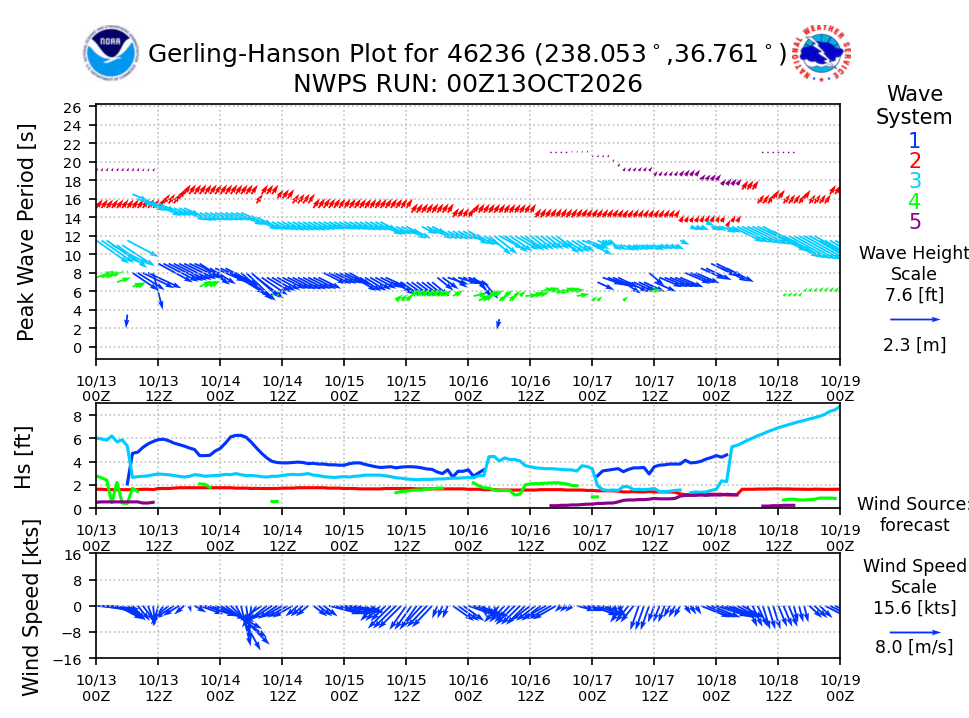
Each color is one swell system; arrow length shows its size. A band at 15 s and up means long-period swell and surge. Times are UTC. View the full forecast at NOAA
Rating logic
- Surge
- The rating turns each swell into a "surge index" in feet: the height that reaches this site, weighted up for longer periods because long swell moves the water harder near the bottom. Here the index moves from Great to Good at 2.1, Mediocre at 3.5, Rough at 4.9 and Stay home at 7 ft. Right now it is 2.9 ft.
- Direction
- Only a narrow slice of northwest swell (about 311 to 343 degrees, between Point Pinos and Santa Cruz) reaches the Breakwater directly. The Monterey Peninsula blocks everything from the west and south; what gets in wraps around, and long-period swell wraps best.
- Wind
- Onshore wind here blows from the NNE. Onshore wind over about 10 kt chops up entries and surface swims; a strong offshore wind (over 15 kt) pushes surface swimmers out. Gusts count for half.
- Tide
- Heights at the Monterey tide station, in feet above mean lower low water. The entry is easiest between -0.5 and 6 ft; tide only nudges the rating.
- Trend and confidence
- The arrow compares the last 9 hours at the buoy with the next 12 hours of forecast; a building long-period swell can push a borderline day one step worse. Confidence is High for a fresh buoy reading or a forecast for the next 12 hours, and drops with lead time, a backup buoy, or a forecast that has been missing the buoy.
- Limits
- A model, not a guarantee: it does not know visibility, local sandbars or what the surf did five minutes ago. Back-tested against dive reports, it matched about 80% exactly and 91% within one level. Always look before you go in.
Sources
- NDBC buoy 46240 (Cabrillo Point) Off Lovers Point. Silent since 2026-04-30; it is used again automatically if it returns.
- NDBC buoy 46236 (Monterey Canyon Outer) At the mouth of the bay; it usually reads 2 to 3 ft higher than the beaches, which the rating accounts for.
- NDBC buoy 46239 (Point Sur)
- CDIP station 158 (buoy 46240)
- CDIP station 156 (buoy 46236)
- NWPS viewer, Monterey office
- NWS point forecast
- NOAA tide predictions, Monterey
- Photo and font credits